

Functions of the surveyor general
Godknows Hofisi
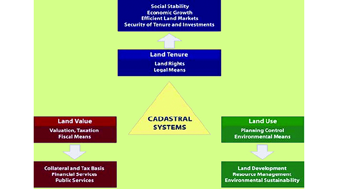
Cadastral system
Land registration system in Zimbabwe follows the cadastral system.
According to Kaufmann (1999) a cadastre can be defined as a methodically arranged public inventory of data concerning all legal land objects in a certain country or district, based on a survey of their boundaries.
Put differently, a cadastral system comprises the map, cadastral register, title and mortgage register.
Registration of rights to land
Rights to land such as title through a deed of transfer, commonly known as title deed, are registered at the Deeds Registry in Harare or Bulawayo.
According to section 21 of the Deeds Registries Act (Chapter 20:05):
lNo portion of any piece of land shall be transferred except upon a diagram thereof and reference shall be made to that diagram in the deed.
Provided that no diagram shall be required if a dispensation certificate has been issued in respect of the land concerned but in such event the deed shall contain a reference to the general plan in which the land is represented.
lOnly the piece of land described in the diagram annexed to a deed of grant or transfer or other title shall be included in such deed.
In terms of section 40 of the Land Survey Act (Chapter 20:12) no general plan or diagram of any piece of land shall be accepted in the Deeds Registry in connection with any registration therein of such land unless such general plan or diagram has been approved by the Surveyor General.
Focus of this article
This article seeks to explain the duties of the Surveyor General’s office in the cadastral land registration system in Zimbabwe.
Duties of the Surveyor General In terms of the website of the Department of Surveyor General (“DSG”), the department is a statutory organisation which owes its existence to the Land Survey Act (Chapter 20:12) (hereinafter “the Act”) which mandates the DSG to undertake administration, regulatory, advisory and technical functions pertaining to land, aerial and space surveys and mapping, as well as storage and provision of Geo-information obtained in relation to Zimbabwe.
According to section 7(1) of the Act the Surveyor-General shall be in charge of the Surveyor-General’s office and he shall, subject to this Act—
(a) supervise and control the survey and charting of land for purposes of registration in the Deeds Registry;
(b)supervise and control all matters pertaining to aerial and space surveys conducted and geo-information obtained in relation to Zimbabwe;
(c)take charge of and preserve all records appertaining to surveys of land which were, prior to the 1st May, 1933, preserved as records in the Surveyor-General’s office, or which may become, after such date, records of the Surveyor-General’s office;
(d)examine all general plans and diagrams or surveys of land before any registration of such land is effected in the Deeds Registry, and approve all such plans and diagrams if he is satisfied that such surveys have been carried out in such a manner as to ensure accurate results, and that such general plans and diagrams have been prepared and the boundaries of the land surveyed have been defined in accordance with the regulations;
(e)on the diagram of any piece of land—
(i)define the geometrical figure representing any portion of such land, the transfer deed whereof has been registered in the Deeds Registry, and deduct the numerical extent of such portion;
(ii)define the geometrical figure representing any portion thereof for which a certificate of township title or a certificate of registered title has been issued, and deduct the numerical extent of such portion;
(iii)define the geometrical figure representing that portion of the land in respect of which a real right or lease has been registered where the registration has been based on a diagram approved by the Surveyor-General;
(f)cancel or amend in accordance with any enactment any general plan or diagram;
(g)prepare, certify and issue at the request of any person, and on payment by such person of such fees as may be prescribed, copies of diagrams and other documents filed in his office, which are available to the public, and copies of general plans and diagrams registered in the Deeds Registry;
(h)conduct such surveys as the Minister may direct;
(i)prepare such maps as the Minister may direct;
(j)take charge of and preserve all records relating to surveys conducted in accordance with paragraph (h);
(k)prepare and maintain lists of official control points;
Work done by surveyors
Work done by surveyors has to be submitted to the Surveyor General and considered by the DSG in terms of the duties explained above. Many people may be familiar with general plans or diagrams which are required for purposes of title deeds.
Duties according to the website of the Department of Surveyor General
Functions
These include examination and approval of survey records, controlling and conducting cadastral surveys, development and maintenance of a national cadastral information system, deeds notation and deductions, training, examination and certification of land surveyors and carrying out title surveys for the issuance of 99 year leases.
Cadastral administration
Includes preliminary examination of surveys, administration of the Land Transaction System (LTS), advising the public on surveying and registration procedures, preparation of Certificates of Conversion of Area and remaining extents, liaison with stakeholder departments and preservation of survey records.
Drawing office
Covers maintenance of the Cadastral Index Maps, reframing of lost diagrams or general plans, deed registry deductions, effecting legal cancellation of diagrams and general plans and adding necessary endorsements to diagrams and general plans.
Technical examination
Pertains to detailed examination of surveys, examination of returned surveys, generating correspondence for returned and approved surveys and dispatching of approved surveys.
Professional examination
Covers approval of examined surveys, examination of sectional title plans, execution of cadastral and topographical surveys and training, examination and certification of land surveyors –in-training.
Disclaimer
This simplified article is for general information purposes only and does not constitute the writer’s professional advice.
Godknows Hofisi, LLB(UNISA), B.Acc(UZ), CA(Z), MBA(EBS,UK) is a legal practitioner / conveyancer, chartered accountant, corporate rescue practitioner, registered tax accountant and consultant in deal structuring and is an experienced director of companies. He writes in his personal capacity. He can be contacted on +263 772 246 900 or [email protected]


You Might Also Like
-
President Mnangagwa today tours exhibition stands and engages with business leaders from diverse sectors at the 64th edition of the Zimbabwe International Trade Fair. Join The Herald Online live from the ZITF grounds in Bulawayo as we give you real-time updates of the proceedings 11:45 12:24 President Mnangagwa has commenced his tour of ZITF exhibition stands. He […]


Agriculture Journal

Comments