

EDITORIAL COMMENT: Council needs to sort out Harare drainage urgently
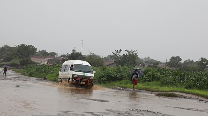
Flooding in Harare Metropolitan is not new since every year some part of the area sees houses semi-submerged, families having to be evacuated or at least self-evacuate, and the streams and rivers in the province and its surrounding areas going from tiny trickles to hard flowing torrents within hours of some decent rainfall.
This year the main flooding has forced people living in close on 100 houses, each the home of an ordinary family, to move out after a day or two of persistent rainfall as parts of the Marimba and Nyatsime Rivers spread in western Harare and Chitungwiza. Emergency Government efforts provide support to the evacuated.
These emergency efforts should not be needed. The problems need to be fixed permanently. Zimbabwe’s climate is well known, and the effects of heavy rain on built up areas and the resulting far greater run off are not secret knowledge.
The main responsibility for dealing with the drainage of the appalling urban sprawl over greater Harare belongs to the urban local authorities of Harare City Council, Chitungwiza Municipality, Epworth Local Board, and Ruwa Local Board, plus the new planned and unplanned suburbs in the bordering rural district councils of Goromonzi, Seke, Zvimba, and now Mazowe.
Some co-ordination is possible within the metropolitan province, although the councils dislike talking to each other let alone acting together, but the urban sprawl has spread way beyond the provincial boundary.
It now requires a major co-ordinated effort to sort out the mess rather than one council dumping its storm water, silt, garbage and perhaps untreated sewage, on the next council in line.
These councils have done almost nothing in recent decades. Some inherited some serious drainage works created over the last 130 years.
All are faced by semi-planned suburbs created by land barons who simply could not care, along with developers who should care, but who are ignorant.
They are also faced by residents who fill natural rivers and streams plus drainage ditches with rubble and garbage. Siltation is getting a lot worse as development spreads to stream and river banks and developers encroach on wetlands. Harare and its surrounding areas have a complex drainage. The urban sprawl is largely drained by one major river and six reasonably important rivers and much of the rainfall eventually runs off into the four supply dams providing the raw water for the two treatment plants.
Running through the southern centre of the province, splitting Harare and Chitungwiza, is the one major river, the Manyame, which although it rises near Marondera now has little flow until it reaches the urban sprawl because of the multitude of farm dams on its rural tributaries.
Until recently planners managed to keep housing away from this river, but the last decade has seen housing move very close to its banks, so there is a disaster brewing there.
The other six rivers are smaller, five of them being tributaries of the Manyame and one a tributary of the Mazowe, but these five which once ran quite comfortably through wooded farmland and were buffered by extensive wetlands, are now with their own tributary streams surrounded by urban development with densities rapidly rising despite the urge of city residents to move ever further out into the surrounding rural district councils so they can have larger plots.
Draining central Harare is the Mukuvisi, the most altered with drainage works on some tributaries starting in the 1890s. The major wetland between the Kopje and the eastern posher side was drained and the stream canalised into a ditch now running under Julius Nyerere Way, and the wetland south of the police and prisons reserve between Eastlea and Newlands drained into a major ditch soon after for malaria control.
Over the decades ever more drainage has been dug, although some forward thinking near its headwaters did create a series of parks that help to modify flooding.
But as the river collects the city centre runoff and then flows through the ever denser southern suburbs flooding dangers rise. We have already seen flooding in Houghton Park where the river goes through two right angles.
To the west of the Mukuvisi basin is the Marimba basin. Its eastern arm starts on the grounds of the University of Zimbabwe, and large sections were canalised to drain the wetlands that decades later allowed the development of southern Avondale and neighbouring suburbs. But the western arm running down from Marlborough through flattish seasonal wetlands was largely on farmland or draining mini-farms until recently, and now probably needs heavy work to prevent the sort of flooding we see in western Kuwadzana.
And once the arms meet there is a lot of water, hence the Budiriro Extension floods and the need for some serious engineering. To the northeast is the Umwindsii catchment, the southern arm starting in Manresa and running though Mandara and Glen Lorne, the central arm starting by Gun Hill and the northern arm draining Borrowdale.
This catchment was under the 1980s master plan supposed to be reserved for low density housing, since the river ends up in the Mazowe.
But cluster housing and other major development have increased runoff dramatically, as was seen a few years ago in Borrowdale Brooke before some private engineering works and there is potential flooding brewing there.
Much of the drainage area is undulating hills so as long as development does not get too close to streambanks, a big if, perhaps it may be safe except on the flatter valleys.
To the north is the Gwebi catchment, starting by Hatcliffe and running west. Development is moving rapidly into the basin in northern Mount Pleasant, northern Marlborough and now the Mount Hampden area and the east of Zvimba Rural District Council, and despite some hilly terrain the natural drainage is likely to be overwhelmed soon unless some serious combined planning is done.
The Nyatsime River running from east to west through southern Chitungwiza drains much of that town and the new, often unplanned, development to its south. The increasing runoff we are now seeing has caused flooding that was not expected more than 40 years ago when the town was founded. And it will get worse.
The Ruwa River catchment, which drains south Goromonzi, Ruwa, Mabvuku-Tafara and Epworth sees that river going into flood more frequently as development increases, and despite hilly terrain needs careful planning to avoid flooding near the banks of the river and its streams. A new problem is now likely to arise with the Muzurura, to the west of the Marimba, as urban development spreads from Harare into Zvimba, much of it with inadequate planning. We are creating new drainage problems. This whole collection of sub-catchments needs, desperately, modern planning to avoid flooding of homes and businesses.
Preserving wide enough wetlands along the rivers to absorb flash floods will help, as will some serious engineering. There is the opportunity, which our children will admire, for more parkland near the rivers, but in many areas it is now too late as housing reaches the river banks and densities rise. This is why we need a new master plan urgently and joint action by the four urban councils and the four affected rural district councils, and perhaps even an extension of the metropolitan boundary to encompass the whole continuous urban sprawl so a provincial approach can be taken.
But the existing province, home to most of the population, can make a start and bring in the rural district councils for this matter. Otherwise the piecemeal approach will just create new problems over the next few decades.


You Might Also Like
-
Wallace Ruzvidzo-Herald Reporter Zimbabwe is on course to host the forthcoming SADC Summit in August, VP Chiwenga said yesterday after touring the Liberation City in Warren Park, roads under construction in Mt Hampden and Julius Nyerere Way in central Harare, to assess progress. Speaking to the media after touring the Liberation City, where he visited […]


Agriculture Journal

Comments