


Time to prepare for veld fires
Sydney Kawadza Senior Features Writer
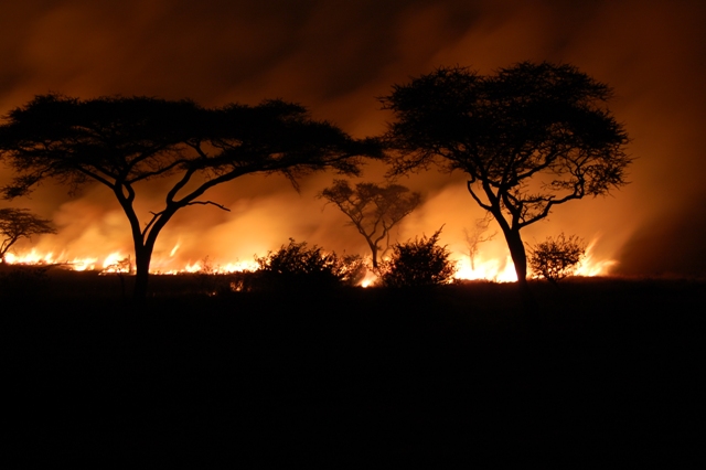
Rolling mountains and hills of charred tree stumps, laid bare of the lush green grass that once covered the landscape during the rains, are all that is usually left after yet another veld fire season. The devastation is immeasurable as trees, grass and animal species are consumed in the rampaging inferno that would have cut across the country. These are the likely scenes that could be experienced in Zimbabwe as we head towards the fire season.
The veld fires this year could be bigger and more devastating after the incessant rains.
According to Environmental Management Authority, the La Nina and Cyclone Dineo rains have supported vegetation growth which when dry provides fuel load conducive for fire outbreaks.
EMA spokesperson Mr Steady Kangata said predictions are indicating the possibility of wild and fierce fires during the dry period the 2017 fire season.
“As such, EMA urges all stakeholders; Government ministries and departments, farmers, motorists and the general public to undertake fire pre-suppression measures by reducing biomass through hay bailing, thatch grass combing and fire guard construction,” he said.
Forest fires are one of the causes of land degradation that lead to deforestation and desertification.
Seven people died during the 2016 fire season.
Property worth $84 787 and plantations valued at $152 736 were destroyed by the veld fires.
Agricultural produce, farm equipment and livestock valued at $4 046 were also demolished last year.
A total of 1 652 fire incidences were recorded resulting in 1 197 335 hectares of land being destroyed.
In the 2015 fire season, 1 881 fire incidences destroyed 1 336 747 hectares of land.
“This translates to 10 percent reduction in the area destroyed by veld fires and a 12 percent reduction in fire incidences,” EMA said.
Mashonaland West recorded the highest fire incidences which consumed 631 622 hectares.
Significant fires were also recorded in Mashonaland Central (188 219 ha), Matabeleland North (157 550ha) and Mashonaland East (112 729ha).
The majority of the fires were recorded in new resettlement areas destroying 599 444 hectares while another 145 484 ha were destroyed in communal areas.
Protected areas were also not spared with 22 292ha lost on forest lands while a further 106 899 destroyed in national parks.
The 2016 fire season cost the nation $241 569.
EMA Geographical Information Services and Remote Sensing Expert Mr Ntando Nondo said the rains means growth in biomass.
Mr Nondo has developed a fire prediction model using vegetation.
“The high biomass translates to high risk in the fire prone areas. It is important to start early fire suppression measures,” he said.
Biomass is the total amount of living matter, usually plants within a given area.
Mr Nondo said using biomass and the Normalised Difference Vegetation Index (NDVI) as a proxy for biomass, EMA is able to map the susceptibility to fires in Zimbabwe.
“Biomass represents an important variable in the fire equation which is matter that when dry and there is an ignition, burns,” he said.
In predicting fire risk in Zimbabwe, biomass and the 2016 fire season behaviour is used to predict the current fire risk.
A veld fire can be a real ecological disaster, regardless of whether it is caused by natural forces or human activity.
Mr Nondo said while it is impossible to control nature, it is possible to map veld fire risk zones minimising the frequency of fire and avert damages.
Veld fire risk zones are locations where a fire is likely to start, and from where it can easily spread to other areas.
“Anticipation of factors influencing the occurrence of fire and understanding the dynamic behaviour of fire are critical aspects of fire management.
“A precise evaluation of veld fire problems and decisions on solution methods can only be satisfactorily made when a fire risk zone map is available,” he said.
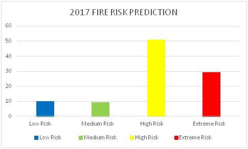
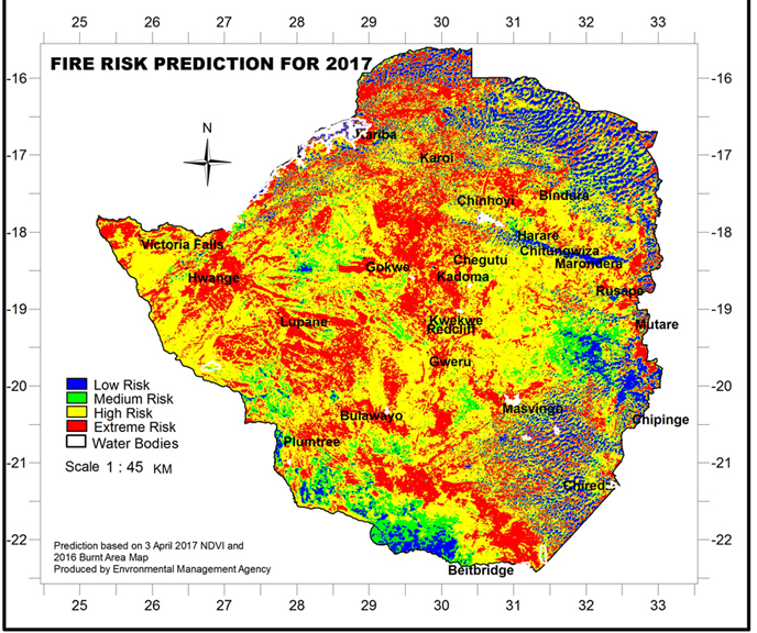
According to the 2017 fire prediction done using vegetation of April 3, 2017 and the 2016 burnt area, fires are likely to be more frequent this year.
The projections range from high to extreme fire risk for the greater part of Zimbabwe.
The 2016 fire season, according to EMA, was in the medium to high risk.
Areas that over the years had a relatively low veld fire rate have been reclassified as high risk in 2017; these include Beitbridge, Gokwe, Hwange and Masvingo.
“There is need to increase fire awareness and management in the high to extreme fire risk zones of the country,” Mr Nondo said.
Sadc’s Monitoring for Environment and Security in Africa thematic expert Mr Farai Marumbwa said, in general, good rains mean more fuel load which translate to more fires during the dry season.
“The most important thing is the drying of vegetation which supports ignition. The intensity of resulting fires also depend on previous fires.
“So in principle, a good season means more work for such organisations as EMA and other associated organisations in the region, who need to come up with strategies like awareness campaigns and maintenance of fire breaks.”
Mr Marumbwa said the best approach for the region is make sure that firebreaks are well maintained especially in areas with high biomass loads.
“The member states should take advantage of the MESA wildfire station to monitor the wildfires during the fire season.
“These stations are installed mostly in departments within the ministries of environment,” he said.
The impact has been felt in protected areas.
Zimbabwe Parks and Wildlife Authority senior ecologist at Matopos National Park Mr Colum Zhuwau said in history, wildlife sanctuaries have been prone to fires.
“This has prompted management to continuously review its fire management plan and framework of operation to reduce fire incidences,” he said.
Mr Zhuwau said despite the huge effort made in activities to reduce the impact of fires, one fire event that was experienced on October 26, 2016 in the park, was catastrophic.
The fire started off in the communal area of Gulathi in the north-eastern boundaries of the park, going through to the western side causing a trail of damage.
A leased tented concession in the park — Rowallan Park — was burnt to the ground and property in excess of $20 000 destroyed.
On the other side, a private lodge, Matopo Ingwe Lodge, lost property worth $50 000 in the inferno.
The fire destroyed an area covering 33km2 was burnt, which is about seven percent of the park.
Mr Zhuwau said heavily linked to the yearly occurrence of fires in Matopo is the marked succession of vegetation occurring within the park.
“A combination of historic information, aerial photographs and satellite imagery are indicating an inclination towards bushes and thickets in areas that used to be vleis and grasslands.
“As vegetation succession occurs, so does wildlife habitation as animals move to areas suitable for their habitats.
“This has thus caused animals to move away from areas they were used to be popularly seen,” he said.
In its Veld Fire Awareness, the Limpopo Provincial Government in South Africa notes that all veld and forest fires are managed under the country’s National Veld and Forest Act (1998).
This law defines a veld fire as a “veld, forest or mountain fire, where veld means the open countryside beyond the urban limit or homestead boundary”.
Veld fires, according to the provincial government, are therefore any fire which occur outside the boundaries of urban build areas and pose the potential of running out of control.
“Veld fires are actually naturally stored solar energy that is out of control? That’s because trees convert all that sunlight into oils that get stored in leaves that end up burning like petrol.
“Many of our natural areas are fire adapted they need regular fires in order to keep healthy and reproduces. This is called the fire regime, it differs according to the ecosystem.
“Veld fires can lead to regeneration of local plant life. Fires that burn too frequently change the combination of plant types and can lead to plant extinctions.”
In maintaining veld fires, it calls for the stabilising of bare ground firebreaks, which are no longer needed, as of barriers such as streams, lakes, ponds, rock cliffs, roads, field boarders, skid trails, landings, drainage canals, railroads, cultivated land, or other areas as existing firebreaks.
“Electric lines – hazardous in heavy smoke – may conduct electricity. When using barriers consider the effects of wildlife and fisheries and locate firebreaks near ridge crests and valley bottoms,” it advises.
The provincial government further calls for the creation of wind predictable-firebreaks located perpendicular to wind and on windward side of the area protected.
The Sadc Regional Fire Management Programme Document notes that in the last two decades, vegetation fires have become a major concern in the region.
The fires have had a negative impact on the environment and humans’ welfare.
“Uncontrolled (un-prescribed) wildfires cause forest and vegetation degradation and related biodiversity loss resulting in immediate and long-term impacts on the livelihoods of local communities and upstream impacts on national and regional economies.
“Fires in the tropical environment are a major contributor to tropical forest degradation, where over time frequent fires lead to savannisation in these areas.”
The regional fire management further states that vegetation fires play a significant role as a major source of trace gases and aerosols in the atmosphere.
These, according to the document, contributes to the anticipated climate change, particularly in emissions of carbon dioxide, fixed in the biomass, as the important ‘greenhouse’ gas.
The regional fire management programme also provides a framework for cooperation on fire management issues across national boundaries.
Fire management is a technical, socio-cultural and political challenge that requires an effective network of willing partners that include governments, the private sector, local communities and international partners.
These have to find the appropriate balance between developing and conserving natural resources and managing unwanted fires while at the same time promoting the safe use of beneficial fires.
Feedback: [email protected]


You Might Also Like
-
AS the ZiG continues to strengthen, gaining just over 2,2 percent against the US dollar since its launch two and half weeks ago, it has now been fully accepted by the formal Zimbabwean business community, including those who had tried to switch to pure US dollar transactions. The important regional airline fastjet is now accepting […]


Agriculture Journal

Comments