


Nature’s exhaustless generosity
Isdore Guvamombe
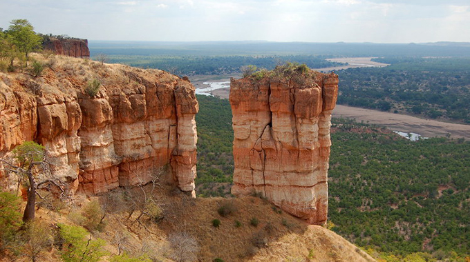
Nature by its own nature is generous and benevolent. Nature is amazing and its exhaustless generosity at times manifests through what it feeds the eye to. If you want to experience nature’s life-changing exhaustless generosity go to Chilojo Cliffs in Chiredzi.
The sun wasn’t yet up but the sky was already softly aglow — a misty gold and yellow hue. An ethereal fog swirled over the cliffs, forming a low-slung cloud bank out of which rose a spectre of hills and mountains.
It looked like a line of ghosts from where I stood on the back of a truck. All around dew drops glinted on mopane, baobab, acacias, cobwebs, mosses and the wings of dragon flies.
Suddenly the serenity was broken by a herd of elephants, making all manner of noises as they scoffed their breakfast. They never looked worried of my presence.
In tow was a herd of zebras. I tried to snap photos but they shot off like bullets, attracting the attention of elephants that seemed to notice me for the first time.
The sun rose imperceptibly and the Chilojo Cliffs bravely shouted: “Good Morning Zimbabwe!” shaking off the lethargy of sleep.
The Chilojo Cliffs are one of the most prominent natural features of the Gonarezhou National Park. Visible from 50km away, morning and evening light give the cliffs a rich hue and dramatically silhouette the distinctive baobab trees.
These trees are the source of the famous “cream of tartar”. The flowers are pollinated by bats and are a delicacy for antelopes. Composed of oxide-rich sandstone, the cliffs are spectacularly colourful at sunset.
South and south-east of Chiredzi in Zimbabwe, the slightly uneven Pliocene erosion surface extends across the Karoo sediments, basalts and granophyres, at an elevation of approximately 380 metres.
Along the northern boundary of the Chipinda Pools area of the Gonarezhou National Park, the Chiwonje Hills form a north-east-trending ridge with summit plantation.
The highest points at Makamandima (578m) and Mutandahwe (571m) are in accord with the lowest position of the Post-African erosion surface to the north.
The northern scarp of the Chiwonje Hills coincides with the basalt-granophyre contact, thereby showing the greater resistance of the more acid rocks.
West of the Runde River this same belt of resistant marginal granophyre gives rise to the Sibonja Hills.
The Chilojo Cliffs (previously called the Clarendon Cliffs) are composed of the coarse, terrestrial Jurassic, Cretaceous sandstones and conglomerates named the Malvernia Beds by Cox (1963), which occupy the extreme south-eastern corner of Zimbabwe.
The cliffs trend east-west for approximately 20km immediately south of the Runde River and 180m above the river course.
The form of the cliffs is two-fold, with the near-vertical lower and upper sections separated from each other by a gently-sloping terrace up to 500m wide. This terrace is scored by gullies which cut through the lower cliff to the river bed.
South of the cliff face, the bevel extends into Mozambique territory at an altitude of approximately 370m, thereby forming the Chilojo Plateau.
This is clearly an erosion surface and is regarded as the Pliocene level. Eroded into the Chilojo Plateau are several small valleys and stream courses, lie the Nyamasikana River which, together with the Runde River and the widespread terrace along its northern bank, comprise the Quaternary erosion cycle.
Eastward, towards the confluence of the Runde and Save rivers, the Chilojo Cliffs fade out and the descent from the Plateau to the river bed is gentle with the two cycles merging into each other through a composite zone.
A line of waterfalls, all within the granophyre outcrop in the central belt of the Gonarezhou National Park marks the nick-point between the Pliocene and the Quaternary cycles on the northern side of the Runde River. They include the Chiviriga Falls on the Runde River, the Dumbwe Falls on the Pombadzi River and the Chivirira Falls on the Save River.
The confluence of the Runde and Save rivers stretches across several square kilometres of flat river bed, sandbanks and the Rupembi Swamp. Here wildlife gather for the life-saving water.

You Might Also Like
-
Arts Reporter A concert was held to mark the launch of a campaign against drug and substance abuse, early marriages and gender-based violence in Dzivaresekwa, Harare, on Saturday. Dubbed mini independence celebration, the event was organised by the Zimbabwe Network for Economic and Social Transformation (ZINEST). It was held at Padziva Camp in the high-density […]


Agriculture Journal

Comments