


Satellite-based flood monitoring boosts disaster response
Jeffrey Gogo Climate Story
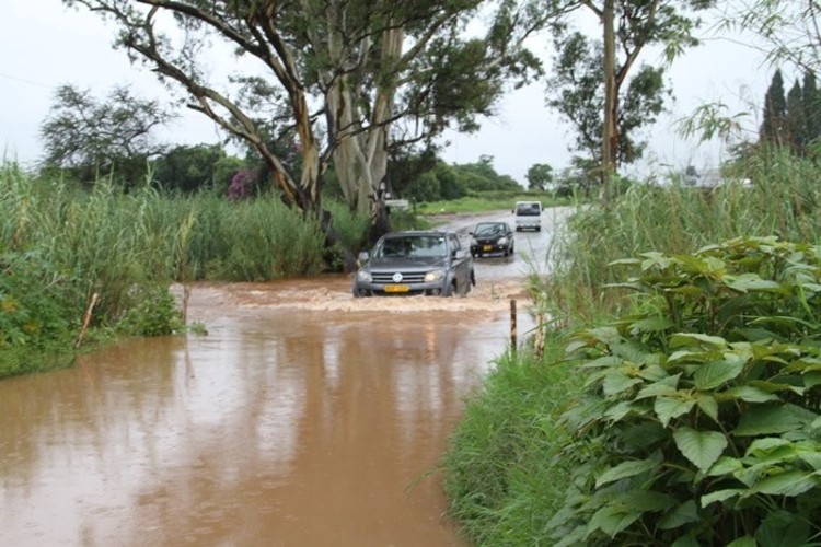
SINCE last October, torrential rains have pounded much of Zimbabwe, causing rivers, including Save, the country’s biggest, to overflow, with dozens of dams spilling, and thousands of acres of cropland swamped. By the first week of February, more than 100 people had died, over 1 000 homes destroyed and 40 schools damaged while entire villages in the low veld had been completely cut off as bridges collapsed, according to the Civil Protection Unit (CPU).
The flood has been destructive, but within days of the flood occurring the CPU, and charities including the Red Cross and Care International had started distributing food and tents to those affected, a fairly quick turnaround compared to the years before.
This is thanks largely to a new satellite-based technology developed by scientists at the University of Zimbabwe in 2016 that monitors flood events as they occur.
A team of scientists led by Amos Murwira, a geo-information science and earth observation professor, have been tracking Zimbabwe’s weather and flood events from their lab at the University, and from another station at water regulator Zinwa, using data obtained from the new technology.
Developed over a year, and unveiled mid-2016, the tool tracks water-flow following a rainfall event using satellite, predicting with some precision the likelihood of a flood within a day or so, says Professor Murwira.
That tool has been deployed most effectively since inception, he said, helping institutions such as the CPU respond much quicker to the current deluge.
The flood monitoring mechanism is also being used to track Cyclone Dineo, which entered southern Zimbabwe on Thursday, and was expected to spread northwards and eastwards into usual hotspots like the Save Valley and Muzarabani, with devastating winds and rain of over 100mm in a day.
“The system (flood monitoring) is now in operation at Zinwa, and national reports based on it are now at the Civil Protection Unit,” Professor Murwira said, by telephone.
“It is helping make decisions in the national Civil Protection Committee meetings (where he is a member), and right now they are monitoring Cyclone Dineo using the same technology.”
Intelligent methods
With a limit in the accuracy of meteorological information needed to help make key decisions at times of disaster, satellite tools can be very useful for evaluating ground conditions, providing important data for aid workers.
Through specialised computer models, the University of Zimbabwe scientists have managed to calculate and predict the probability of floods, or lack thereof, of different catchments based on the information they already know about those specific areas.
In the end, what you get is a series of maps tracking the water flow following a rainfall event, including the flood’s build up and recession.
Professor Murwira has said in a previous interview that: “Our job is to be able to interpret satellite rainfall using intelligent methods to convert that rainfall into runoff, and secondly, to determine the runoff above which a certain threshold, it now constitutes a flood.”
The “threshold” is the level at which a river is said to have filled up, its banks bursting and allowing water to flood surrounding areas.
Sibusisiwe Ndlovu, deputy director general at the CPU, was coy when asked of the new satellite technology, preferring brief, vague responses.
“It’s useful as we can get early warning real time instead of relying on the hydrological stations,” she said, without going into detail on how exactly the tool had aided disaster preparedness and response in Zimbabwe. Barring the perennial spending limits, the Civil Protection Unit has this time around been most effective in its communication strategy under Mrs Ndlovu.
The Unit has deployed new mobile-based technologies with ruthlesss efficiency, blasting subscribers with SMS texts on an almost daily basis.
Its latest warning relates to the cyclone that has crossed over into Zimbabwe from Mozambique.
“Beware of dangers of strong winds and floods from Cyclone Dineo and save lives. In case of emergency dial 112,” the CPU warns.
Better times ahead
At the Zimbabwe National Water Authority (ZINWA), which manages the country’s water resources, the Professor Murwira’s flood monitoring technology has yet to gain full traction after being installed there a couple of weeks back.
Debra Musiwa, a hydrology expert with ZINWA, told The Herald Business that results from the satellite system had yet to be validated because it was still new. In the meantime, the authority has had to combine its old fashioned prediction models with the new one.
“We are currently integrating this new software with our traditional methods of flood monitoring and using both methods for flood monitoring,” said Musiwa, by email.
“We are hoping the final product will be able to compute the flood extent from the runoff generated.”
The integration of the UZ’s satellite technology into national systems, for use by national institutions, demonstrates the kind of relationship that ought to exist between universities and public institutions in driving research and development.
Such an alliance has been mostly lacking, with Government failing to adopt recommendations from or technologies developed by local universities on various socio-economic matters.
“We feel humbled by the fact that the state Government is recognising the university’s efforts in economic development,” Professor Murwira said. Studies show that rainfall patterns in Zimbabwe are no longer as predictable.
Since the early 1900s, rainfall has dropped sharply in November, January, February and March, with the onset periods becoming erratic.
Rains in October and November and December have become “more violent and destructive,” leading to frequent flash flooding, according to a 2013 paper by Meteorological Services Department director Dr Amos Makarau.
Strong winds like tornadoes are now common place, he said, blaming the changes on climate change.
God is faithful.


You Might Also Like
-
Victoria Falls Stock Exchange (VFEX) listed property firm, WestProp Holdings Limited says it has a solid multi-billion-dollar projects pipeline that spans residential and commercial segments that are expected to be implemented concurrently during the current financial year.


Agriculture Journal

Comments